
Hurricane Lane is the greatest weather threat to Hawaii in decades, say storm experts.
"Hawaii is going to be impacted by Hurricane Lane. The question is, how bad?" FEMA administrator Brock Long told reporters Thursday.
Hawaii governor David Inge is urging residents of all islands to set aside two weeks' worth of food and water and to shelter in place where there are insufficient shelters. At the time of this blog post, Hilo, on the big island of Hawaii, has already registered 18 inches of rainfall.
VIDEO, below: View the eye of Hurricane Lane at its peak intensity, Category 5. The video was captured by a NOAA Hurricane Research Division flight that passed through its center.
Video of #NOAA42 entering the eye #HurricaneLane during the 4PM HST mission. The storm was near its peak intensity, a Category 5, at this point. Taken by L. Bucci. pic.twitter.com/TTTzM23xwy
— HRD/AOML/NOAA (@HRD_AOML_NOAA) August 22, 2018
VIDEO, below: The International Space Station passed over Hurricane Lane churning in the Pacific. ISS grabbed these images 254 miles south of the Hawaiian Islands at 12:47pm ET today.
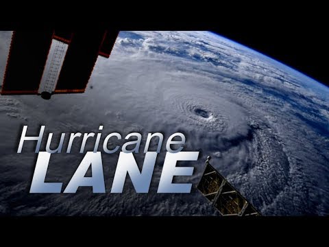
#HurricaneLane in the early morning hours near #Hawaii. The crew of the @Space_Station sends much aloha to everyone there. pic.twitter.com/raPh37MZH9
— Ricky Arnold (@astro_ricky) August 22, 2018
Hurricane Lane's outer bands have been pummeling parts of Hawaii's Big Island with rain Thursday morning, triggering landslides and threatening serious flooding as the Category 4cyclone moves perilously close to the Aloha State.
The center of the storm — which could become the first major cyclone to make landfall in the state in 26 years — is expected to move very close to the main islands or cross land Thursday through Friday, the Central Pacific Hurricane Center said.
The storm's center, with maximum sustained winds near 130 mph, was in the Pacific about 205 miles southwest of the Big Island town of Kailua-Kona around 8 a.m. HT Thursday (2 p.m. ET).

4 rain gauges with over a foot of rain on the Big Island in the last 24 hours, highest is now closing in on 17 inches of rain. #hiwx #HurricaneLane
— Robert Ballard (@firebomb56) August 23, 2018
USACE has deployed 1 Team Leader, 1 Asst Team Leader, 1 Infrastructure Assessment Subject Matter Expert, & 1 Temporary Roofing Subject Matter Expert to assist fed partners w/ planning missions for Emergency Support Function 3 (Public Works & Engineering) support. #HurricaneLane
— USACE HQ (@USACEHQ) August 23, 2018
A prolonged period of heavy rainfall is expected in Hawaii with Hurricane Lane. Here are the impacts of 10-20 inches of rainfall combined with the effects of terrain.
Follow the advice & evacuation orders from your local officials!
— NWS (@NWS) August 23, 2018
I recommend you take everything you can off your lanai tonight. Everything. Secure loose objects in your yard. Bring all of it inside. Start charging up your spare batteries. #hiwx #HurricaneLane
— Robert Ballard (@firebomb56) August 23, 2018
#BREAKING: Hurricane warnings are now in effect for the island of Oahu as well as Hawaii and Maui counties. https://t.co/gFm5QObaAS pic.twitter.com/XBLx801tf7
— Hawaii News Now (@HawaiiNewsNow) August 23, 2018
Had a call w/federal emergency agencies. This storm is quite serious, and current track shows severe rain, wind, and wave impacts, for each island. The federal, state and county governments are mobilized. Please take care of yourself, your ohana, and your home ASAP.
— Brian Schatz (@brianschatz) August 22, 2018
Full flight to Honolulu. At least one member from FEMA and about a half-dozen members of California Task Force 3 – Urban Search and Rescue Team on board this flight to assist as #HurricanLane approaches Hawaii.
— David Montero (@DaveMontero) August 23, 2018
There aren't enough hurricane shelters in Hawaii, so the governor is advising people to shelter in place with two weeks of supplies.
Folks, the national media should be wall-to-wall in Hawaii right now. #HurricaneLane arrives in just a few hours. This is heartbreaking. https://t.co/oATPeZFPUK
— Eric Holthaus (@EricHolthaus) August 22, 2018


